Export Map To Google Earth
Submitted by Mick on Wed, 2009-09-23 15:55.
::
ComStudy To Google Earth
Support for this process is provided only on this forum.
The steps here must be followed - if it didn't work for you, try again.
Warning: This is a tedious process.
Prerequisites: ComStudy, Notepad, Google Earth, IrfanView, this KML
Please notify me (on this site - reply below) if you notice any steps are missing or wish to add more information to this post. Thanks!
RadioCompass Notice:
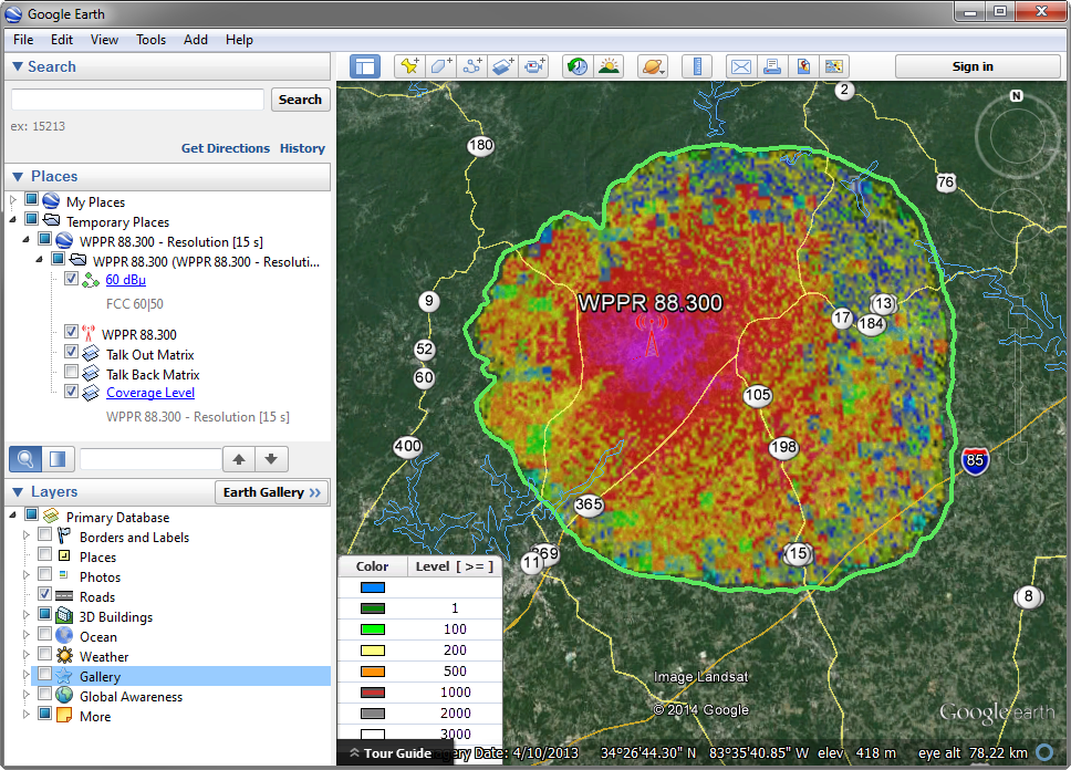
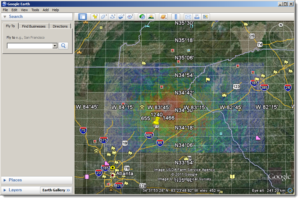
Should you wish to perform this process in only a couple of mouse clicks, contact us at 888-723-4695 for a demo of RadioCompass. Click here for a sample RadioCompass to Google Earth export. Here's a sample image from that export:
ComStudy Export To Google Earth Process
- Create a new study with a calculated matrix or open a saved study.
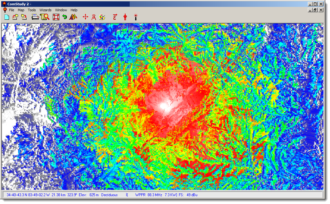
- Configure the map so that only layers you wish to export are visible.
- Note: In my case I like to export only the matrix so I turn off all vector and text labels as seen below.
- Note: In my case I like to export only the matrix so I turn off all vector and text labels as seen below.
- Export the map image to a .bmp image from the FILE menu (File | Save As Bitmap)
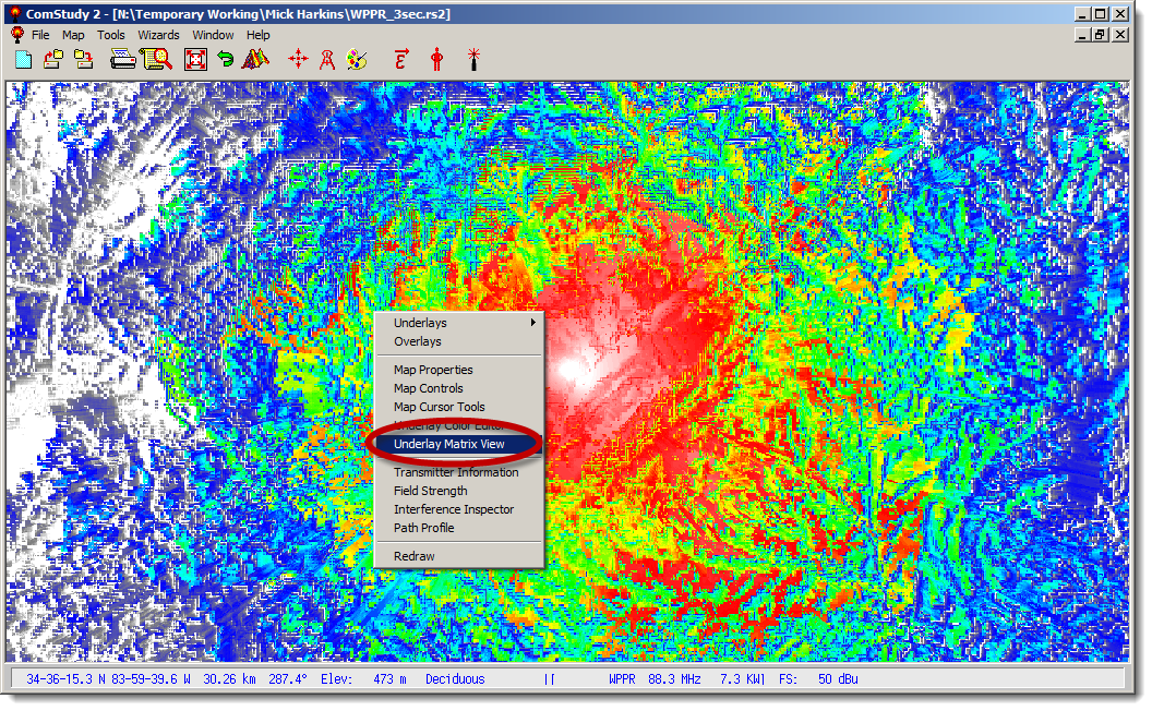
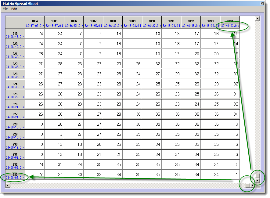
- While still in ComStudy, right-click on the map and go to Underlay Matrix View
- Note: Note that if you have no matrix drawn you will need to turn on an Underlay such as Terrain or Population to open the Viewer.
- Note: Note that if you have no matrix drawn you will need to turn on an Underlay such as Terrain or Population to open the Viewer.
- Now scroll to the top left and get the lat/lon:
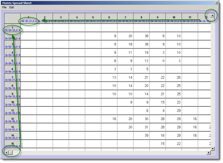
- Now the bottom right - get the lat/lon:
- Convert the lat/lon from D-M-S to Decimal Degrees. FCC does this here.
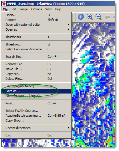
- Open the .bmp file you created in Step 1 in IrfanView
- Choose File | Save As
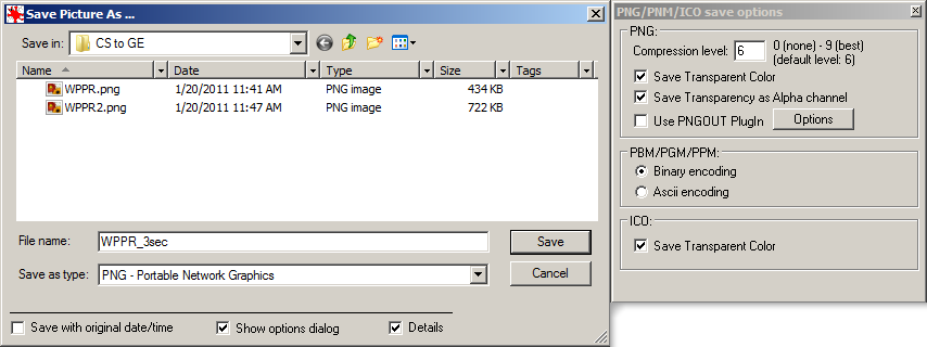
- These options are fine - the Save as type should be set to PNG.
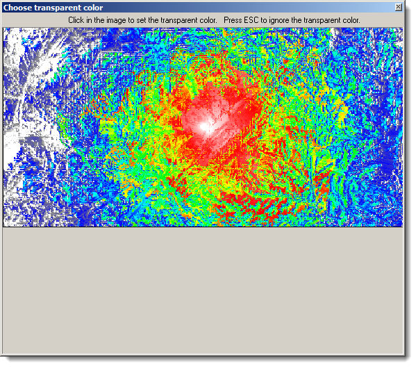
- IrfanView now gives you the option to pick a transparent color - usually you will want to choose white (by clicking).
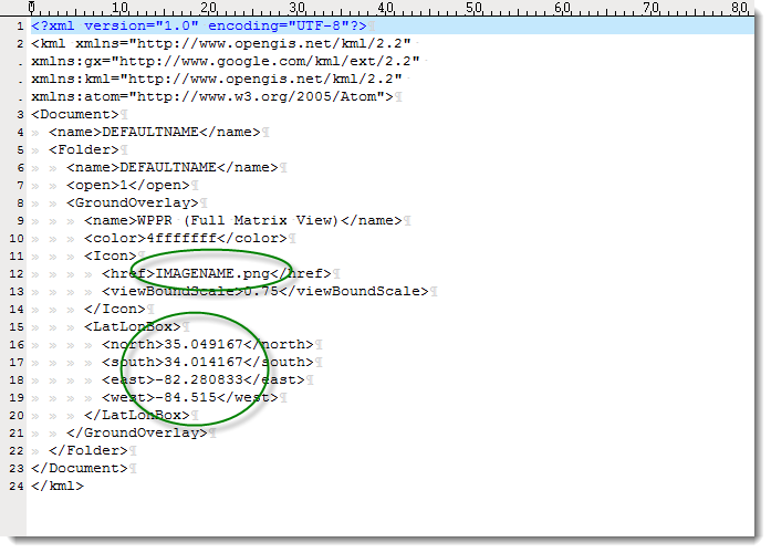
- Edit the attached KML file (also available here) in a text editor (Notepad, TextEdit, UltraEdit, Notepad++) substituting your lat/lon data and image name. Note that the image file and the KML file need to be in the same folder. Also note that you will need to be logged in to this site to see the KML attachment at the bottom of this post.
- Save the KML file then double-click it to open it in Google Earth.
- Pat yourself on the back.
- Login to post comments
pretty cool.
couple comments:
1. "export to bmp" should be "save as bitmap" (if you're literal like me, you'll waste time looking for the "export" feature) ;)
2. In CS, I found turning off everything except for the field strength was best for me as I had all my sites plotted in Google Earth already
3. we use the color white to indicate a field strength level that is too low to use. When viewing the .kml, you get a white box, which is kind of distracting. I edited the image with GIMP to remove the white areas (select by color option)and it's looking pretty nice in Google Earth now!
Thanks Mick!
The only thing I did not like about this was that there was white when the propagation picture got into google earth where there was no signal. It was not bad but I wanted to eliminate any color from the comstudy map other than actual signal strength colors.
I found that prior to exporting the map to a bit map you can eliminate any white by making a changes to the underlay color editor. Basically, under the Underlay Color Editor under MAX FS click on the color for #1 which is generally white, Click on it to change color. Then click on Define Custom color. Then look for where it says red, green, and blue. Change Red to 255, Green 0, and Blue to 255 and Click "OK" in that dialog box and then Click Apply in the Color editor dialog box. On the map you should now see a pink color anywhere there is no signal. Now save as bitmap. Then open the bitmap in irfanview then save it as a GIF and when prompted click on the pink as the color to save as your transparent color. Now you can follow the instrctions as before just make sure you remember to use the correct file name and it is a GIF when you edit the Google file.
Thanks for the feedback and the extra tweaks. I made the "export" change. It's nice to see someone else uses the GIMP!
We used what you started with google earth to export some stuff to google maps. It worked great. A little more complicated but now we have a live search-able version of on contour to put on the internet.
Steps to follow:
1. Obtain Google Maps API Key for your domain here: http://code.google.com/apis/maps/signup.html
2. Export and edit your image as shown above.
3. Edit the relevant fields in the HTML document attached. These are the key field, the image path field and then change the coordinates to work with your map. Works great for us. check out the google map api documentation for more info on what you can do with google maps.
http://code.google.com/apis/maps/documentation/index.html
Jonathan Bowen
RBN/WPCS Field Engineer
Nice! We'd love to see an example! Got a link to the map on your site?
Well we don't have it up yet. I have 43 translators to finish and to get our actual web guys to start the redesign we are working on for it before it can go live. I'll attach the working .html file here that you can just open and should work. It pulls images from my private webserver that I was using for testing. It works on all our computers and it seems a local file doesn't need the API code. I have used several in them and they all work fine.
Jonathan Bowen
RBN/WPCS Field Engineer
New site up and ready to go. Our maps can be seen at www.rejoice.org look under local stations. then hover over a translator name and it will pop-up a contour map
Jonathan Bowen
RBN/WPCS Field Engineer
Thanks! Pretty slick display of the sites. Thanks for sharing it.